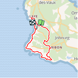
![](/images/other/stat-length.png)
![Tocht Stappen La Hague - Le nez de Jobourg - Baie d'Ecalgrain - Photo](https://media.geolcdn.com/t/1900/400/ext.pjpeg?maxdim=2&url=https%3A%2F%2Fservices.sitytrail.com%2FGeolivesWS%2FDownloadMedia.ashx%3FTrailID%3D316661%26Media%3D3519_1.jpg)
Le nez de Jobourg - Baie d'Ecalgrain
tracegps
Gebruiker
![Lengte](/images/other/stat-length.png)
![Max. hoogte](https://static1.geolcdn.com/siteimages/upload/files/1508320355ic_sort_altitude_max_24dp.png)
![Positief hoogteverschil](https://static1.geolcdn.com/siteimages/upload/files/1508320355ic_sort_den_pos_24dp.png)
![Km-Effort](/images/other/stat-length.png)
![Min. hoogte](https://static1.geolcdn.com/siteimages/upload/files/1508320355ic_sort_altitude_min_24dp.png)
![Negatief hoogteverschil](https://static1.geolcdn.com/siteimages/upload/files/1508320355ic_sort_den_neg_24dp.png)
![Boucle](https://static1.geolcdn.com/siteimages/upload/files/16400158638029165_repeat_loop_refresh_sync_direction_icon.png)
![Stappen](https://static1.geolcdn.com/sitytour/trail-icons/101.png)
4h00
Moeilijkheid : Moeilijk
![Scan deze QR-code om de tocht te openen in de SityTrail-applicatie](https://capi.geolives.com/qq0zvz2zws4bq2lad0pu/sitytour/trails/316661/qr.png?size=200)
Gratisgps-wandelapplicatie
Over ons
Tocht Stappen van 11,8 km beschikbaar op Normandië, Manche, La Hague. Deze tocht wordt voorgesteld door tracegps.
Beschrijving
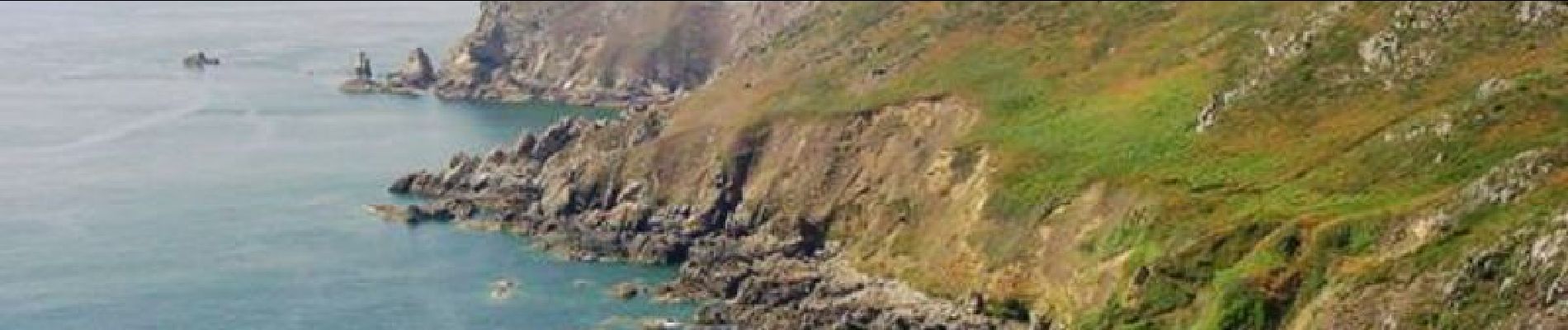
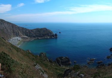
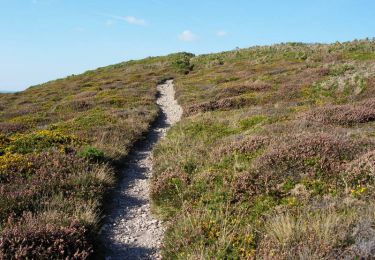
Le Nez de Jobourg est le nom des falaises culminant à 128 mètres et qui figurent parmi les plus hautes d’Europe continentale. Le Nez de Jobourg est utilisé comme poste de surveillance du trafic maritime. Le CROSS-MA, situé à environ 170 mètres de hauteur, surveille la Manche et observe les cargos et tankers au large du Cap. On peut donc admirer le panorama sur le Nez de Jobourg, la pointe de Goury et les îles anglo-normandes, depuis le Nez de Voideries. Au pied des falaises du Nez de Jobourg, il existe plusieurs grottes, aux noms très évocateurs et sources de légendes : le Trou aux Fées ou la Grotte aux Lions, qui ont été façonnées par la mer. D'autres comme la grotte de la Petite Eglise et la grotte de la Grande Eglise qui selon la légende rejoindraient le village via un tunnel, auraient servi de cache pour les contrebandiers. Sur le Nez de Jobourg, classé réserve ornithologique, viennent nicher des cormorans huppés, fulmars, goélands argentés, grands corbeaux. Concernant le Nez de Jobourg, il s'agirait du deuxième lieu le plus visité dans la Manche après le Mont Saint Michel.
Plaatsbepaling
Opmerkingen
Wandeltochten in de omgeving
![Tocht Stappen La Hague - NEZ JOBOURG - Photo](https://media.geolcdn.com/t/375/260/c98676c9-55e7-4381-9b91-05c742077aaf.jpg&format=jpg&maxdim=2)
![Stappen Stappen](https://static1.geolcdn.com/sitytour/trail-icons/101.png)
Stappen
![](/images/other/stat-length.png)
![](https://static1.geolcdn.com/siteimages/upload/files/16400158638029165_repeat_loop_refresh_sync_direction_icon.png)
![Tocht Mountainbike La Hague - Le Tour des Echoués - Jobourg - Photo](https://media.geolcdn.com/t/375/260/ext.jpg?maxdim=2&url=https%3A%2F%2Fservices.sitytrail.com%2FGeolivesWS%2FDownloadMedia.ashx%3FTrailID%3D173186%26Media%3D14770_5.jpg)
![Mountainbike Mountainbike](https://static1.geolcdn.com/sitytour/trail-icons/202.png)
Mountainbike
![](/images/other/stat-length.png)
![](https://static1.geolcdn.com/siteimages/upload/files/16400158638029165_repeat_loop_refresh_sync_direction_icon.png)
![Tocht Stappen La Hague - Ecalgrain et sa baie. - Photo](https://media.geolcdn.com/t/375/260/ext.jpg?maxdim=2&url=https%3A%2F%2Fservices.sitytrail.com%2FGeolivesWS%2FDownloadMedia.ashx%3FTrailID%3D102758%26Media%3D3900_6.jpg)
![Stappen Stappen](https://static1.geolcdn.com/sitytour/trail-icons/101.png)
Stappen
![](/images/other/stat-length.png)
![](https://static1.geolcdn.com/siteimages/upload/files/16400158638029165_repeat_loop_refresh_sync_direction_icon.png)
![Tocht Te voet La Hague - SityTrail - 4202124 - cotentin-j3 - Photo](https://media.geolcdn.com/t/375/260/0edaec19-e94e-4149-8092-0ff358c3dd07.jpg&format=jpg&maxdim=2)
![Te voet Te voet](https://static1.geolcdn.com/sitytour/trail-icons/100.png)
Te voet
![](/images/other/stat-length.png)
![](https://static1.geolcdn.com/siteimages/upload/files/16400158638029165_repeat_loop_refresh_sync_direction_icon.png)
![Tocht Stappen La Hague - Séjour Cotentin Etape 3 Le nez de Jobourg et Biville a corriger - Photo](https://media.geolcdn.com/t/375/260/769074c5-2128-40cd-af27-847ab7c0e7c4.jpg&format=jpg&maxdim=2)
![Stappen Stappen](https://static1.geolcdn.com/sitytour/trail-icons/101.png)
Stappen
![](/images/other/stat-length.png)
![](https://static1.geolcdn.com/siteimages/upload/files/16400158638029165_repeat_loop_refresh_sync_direction_icon.png)
![Tocht Te voet La Hague - Séjour Cotentin Etape 2 Boucle Jobourg La Hague - Port Racine - Omonville la petite - Photo](https://media.geolcdn.com/t/375/260/c0e0de9e-3bd4-4319-af5c-c6b5aff35ffd.jpg&format=jpg&maxdim=2)
![Te voet Te voet](https://static1.geolcdn.com/sitytour/trail-icons/100.png)
Te voet
![](/images/other/stat-length.png)
![](https://static1.geolcdn.com/siteimages/upload/files/16400158638029165_repeat_loop_refresh_sync_direction_icon.png)
![Tocht Stappen La Hague - goury / vauville - Photo](https://media.geolcdn.com/t/375/260/ext.jpg?maxdim=2&url=https%3A%2F%2Fstatic1.geolcdn.com%2Fsiteimages%2Fupload%2Ffiles%2F1553511878bg_sport_marche.png)
![Stappen Stappen](https://static1.geolcdn.com/sitytour/trail-icons/101.png)
Stappen
![](/images/other/stat-length.png)
![](https://static1.geolcdn.com/siteimages/upload/files/16400158638029165_repeat_loop_refresh_sync_direction_icon.png)
![Tocht Stappen La Hague - Magiquement votre - Photo](https://media.geolcdn.com/t/375/260/c49fffc8-7c79-42cf-a4d6-b3c2cf7eec90.jpg&format=jpg&maxdim=2)
![Stappen Stappen](https://static1.geolcdn.com/sitytour/trail-icons/101.png)
Stappen
![](/images/other/stat-length.png)
![](https://static1.geolcdn.com/siteimages/upload/files/16400158638029165_repeat_loop_refresh_sync_direction_icon.png)
![Tocht Stappen La Hague - Boucle St-Germain-des-Vaux - Auderville - La Roche - Goury - Photo](https://media.geolcdn.com/t/375/260/e5808f0a-2966-4fdc-bdca-55912ac6256a.jpg&format=jpg&maxdim=2)
![Stappen Stappen](https://static1.geolcdn.com/sitytour/trail-icons/101.png)
Stappen
![](/images/other/stat-length.png)
![](https://static1.geolcdn.com/siteimages/upload/files/16400158638029165_repeat_loop_refresh_sync_direction_icon.png)